![](/images/other/stat-length.png)
![Trail Walking Le Thoronet - Trace_Thoronet - Photo](https://media.geolcdn.com/t/1900/400/8ba50d89-4322-43c3-92b6-dad72fbe2d40.jpg&format=pjpeg&maxdim=2)
Trace_Thoronet
affinetataille
User GUIDE
![Length](/images/other/stat-length.png)
Length
13.8 km
![Max alt](https://static1.geolcdn.com/siteimages/upload/files/1508320355ic_sort_altitude_max_24dp.png)
Max alt
229 m
![Uphill gradient](https://static1.geolcdn.com/siteimages/upload/files/1508320355ic_sort_den_pos_24dp.png)
Uphill gradient
306 m
![Km-Effort](/images/other/stat-length.png)
Km-Effort
17.9 km
![Min alt](https://static1.geolcdn.com/siteimages/upload/files/1508320355ic_sort_altitude_min_24dp.png)
Min alt
95 m
![Downhill gradient](https://static1.geolcdn.com/siteimages/upload/files/1508320355ic_sort_den_neg_24dp.png)
Downhill gradient
307 m
![Boucle](https://static1.geolcdn.com/siteimages/upload/files/16400158638029165_repeat_loop_refresh_sync_direction_icon.png)
Boucle
Yes
Creation date :
2022-06-28 10:56:39.542
Updated on :
2024-04-04 23:26:04.46
![Walking](https://static1.geolcdn.com/sitytour/trail-icons/101.png)
6h00
Difficulty : Easy
![Scan this QR Code to open this trail in the SityTrail application](https://capi.geolives.com/qq0zvz2zws4bq2lad0pu/sitytour/trails/3297508/qr.png?size=200)
FREE GPS app for hiking
About
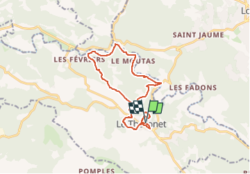
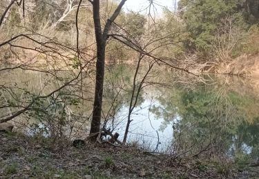
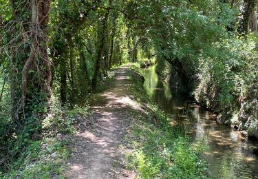
Trail Walking of 13.8 km to be discovered at Provence-Alpes-Côte d'Azur, Var, Le Thoronet. This trail is proposed by affinetataille.
Description
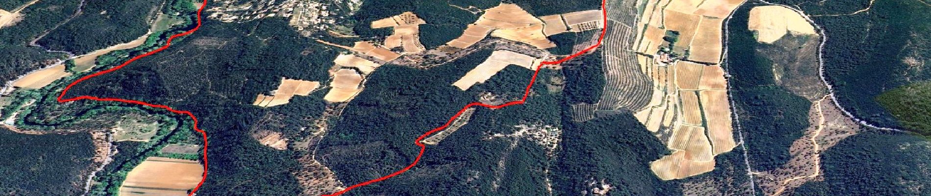
!!!! Entre les Kms 6.0 et 7.5 utiliser la chemin qui longe le canal. Ne passer par la piste en bordure de l'Argens, propriétaires irascibles et chiens peu sympathiques refusant le passage.
Positioning
Country:
France
Region :
Provence-Alpes-Côte d'Azur
Department/Province :
Var
Municipality :
Le Thoronet
Location:
Unknown
Start:(Dec)
Start:(UTM)
281929 ; 4814609 (32T) N.
Comments
Trails nearby
![Trail Walking Le Thoronet - SityTrail - Abbayie de Torronet - Photo](https://media.geolcdn.com/t/375/260/c1345155-8a53-4785-b8e1-556f37370f25.jpg&format=jpg&maxdim=2)
![Walking Walking](https://static1.geolcdn.com/sitytour/trail-icons/101.png)
SityTrail - Abbayie de Torronet
Walking
Medium
(1)
Le Thoronet,
Provence-Alpes-Côte d'Azur,
Var,
France
![](/images/other/stat-length.png)
12.3 km | 16.5 km-effort
6h 0min
![](https://static1.geolcdn.com/siteimages/upload/files/16400158638029165_repeat_loop_refresh_sync_direction_icon.png)
Yes
![Trail Walking Le Thoronet - 2023-01-12 Le Thoronet- Chemin des moines - Photo](https://media.geolcdn.com/t/375/260/a61d5b67-2b87-4718-8049-a50916c47930.jpg&format=jpg&maxdim=2)
![Walking Walking](https://static1.geolcdn.com/sitytour/trail-icons/101.png)
2023-01-12 Le Thoronet- Chemin des moines
Walking
Difficult
Le Thoronet,
Provence-Alpes-Côte d'Azur,
Var,
France
![](/images/other/stat-length.png)
16.5 km | 23 km-effort
5h 17min
![](https://static1.geolcdn.com/siteimages/upload/files/16400158638029165_repeat_loop_refresh_sync_direction_icon.png)
Yes
![Trail Walking Lorgues - Lorgues et l'Ermitage Saint-Ferréol - Photo](https://media.geolcdn.com/t/375/260/e62c5b83-8a2e-4772-82d8-7fdc4c20c935.jpg&format=jpg&maxdim=2)
![Walking Walking](https://static1.geolcdn.com/sitytour/trail-icons/101.png)
Lorgues et l'Ermitage Saint-Ferréol
Walking
Medium
Lorgues,
Provence-Alpes-Côte d'Azur,
Var,
France
![](/images/other/stat-length.png)
5.5 km | 8 km-effort
1h 48min
![](https://static1.geolcdn.com/siteimages/upload/files/16400158638029165_repeat_loop_refresh_sync_direction_icon.png)
Yes
![Trail Walking Le Thoronet - Abbayie de Torronet - Photo](https://media.geolcdn.com/t/375/260/8fc4cfe5-b20b-4ac4-95db-dfa07c3edf80.jpg&format=jpg&maxdim=2)
![Walking Walking](https://static1.geolcdn.com/sitytour/trail-icons/101.png)
Abbayie de Torronet
Walking
Easy
Le Thoronet,
Provence-Alpes-Côte d'Azur,
Var,
France
![](/images/other/stat-length.png)
11.9 km | 15.6 km-effort
6h 13min
![](https://static1.geolcdn.com/siteimages/upload/files/16400158638029165_repeat_loop_refresh_sync_direction_icon.png)
Yes
![Walking Walking](https://static1.geolcdn.com/sitytour/trail-icons/101.png)
Le Thoronet - Mine de bauxite - Église de Béthléem - Les Camails - Clapier - ...
Walking
Easy
Le Thoronet,
Provence-Alpes-Côte d'Azur,
Var,
France
![](/images/other/stat-length.png)
18.4 km | 25 km-effort
4h 17min
![](https://static1.geolcdn.com/siteimages/upload/files/16400158638029165_repeat_loop_refresh_sync_direction_icon.png)
Yes
![Trail Nordic walking Le Thoronet - Le Thoronet - La vigie des Ubacs - Photo](https://media.geolcdn.com/t/375/260/ext.jpg?maxdim=2&url=https%3A%2F%2Fservices.sitytrail.com%2FGeolivesWS%2FDownloadMedia.ashx%3FTrailID%3D512603%26Media%3Dfix__20160112162511.jpg)
![Nordic walking Nordic walking](https://static1.geolcdn.com/sitytour/trail-icons/102.png)
Le Thoronet - La vigie des Ubacs
Nordic walking
Very easy
Le Thoronet,
Provence-Alpes-Côte d'Azur,
Var,
France
![](/images/other/stat-length.png)
7.9 km | 12 km-effort
2h 20min
![](https://static1.geolcdn.com/siteimages/upload/files/16400158638029165_repeat_loop_refresh_sync_direction_icon.png)
No
![Trail Walking Le Thoronet - Abbaye Thoronet - Lac de Carcès rando - Photo](https://media.geolcdn.com/t/375/260/ext.jpg?maxdim=2&url=https%3A%2F%2Fservices.sitytrail.com%2FGeolivesWS%2FDownloadMedia.ashx%3FTrailID%3D405651%26Media%3Dfix__20150408104649.jpg)
![Walking Walking](https://static1.geolcdn.com/sitytour/trail-icons/101.png)
Abbaye Thoronet - Lac de Carcès rando
Walking
Medium
Le Thoronet,
Provence-Alpes-Côte d'Azur,
Var,
France
![](/images/other/stat-length.png)
17.3 km | 24 km-effort
5h 3min
![](https://static1.geolcdn.com/siteimages/upload/files/16400158638029165_repeat_loop_refresh_sync_direction_icon.png)
No
![Trail Walking Le Thoronet - Thoronet Canal de Sainte-Croix - Photo](https://media.geolcdn.com/t/375/260/52be4161-0611-41dd-b691-680f0740539e.jpg&format=jpg&maxdim=2)
![Walking Walking](https://static1.geolcdn.com/sitytour/trail-icons/101.png)
Thoronet Canal de Sainte-Croix
Walking
Difficult
Le Thoronet,
Provence-Alpes-Côte d'Azur,
Var,
France
![](/images/other/stat-length.png)
11.8 km | 15.1 km-effort
3h 52min
![](https://static1.geolcdn.com/siteimages/upload/files/16400158638029165_repeat_loop_refresh_sync_direction_icon.png)
Yes
![Trail sport Lorgues - Tour St Jaumes pont d’argens thoronet - Photo](https://media.geolcdn.com/t/375/260/da27d9c9-7a62-4565-93c2-e4ae64855591.jpg&format=jpg&maxdim=2)
Tour St Jaumes pont d’argens thoronet
sport
Very easy
Lorgues,
Provence-Alpes-Côte d'Azur,
Var,
France
![](/images/other/stat-length.png)
18.1 km | 23 km-effort
Unknown
![](https://static1.geolcdn.com/siteimages/upload/files/16400158638029165_repeat_loop_refresh_sync_direction_icon.png)
Yes